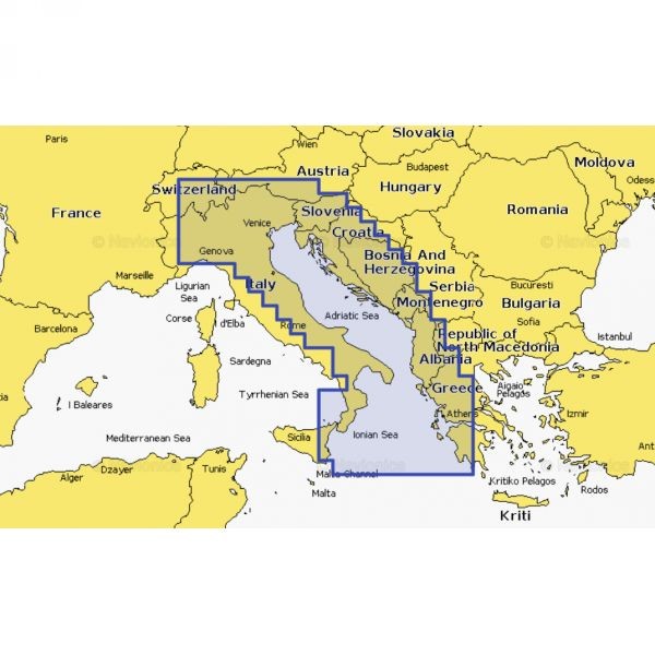
Navionics+ Small chart for the Adriatic Sea (Grado – Zlarin – South Adriatic) provides detailed navigation data, updated charts, and advanced features for safe boating.
Navionics+ Small PROMO (Grado - Zlarin - South Adriatic) is a detailed navigation chart created for boaters who want safer, easier, and more precise navigation across the Adriatic. Covering the area from Grado to Zlarin and the southern Adriatic, it is a practical solution for route planning, coastline overview, and improved orientation at sea.
This chart provides a clear view of essential navigation information that supports everyday boating, whether for leisure cruising, fishing, or more advanced trip planning. Its visual coverage layout helps users navigate with greater confidence and make safer decisions while on the water.
The Navionics+ format is well known for its practicality and clarity, and this product is especially useful for users looking for reliable Adriatic Sea coverage in a compact regional format. It is intended for use with compatible navigation devices and systems that support Navionics cartography.
Key features
Coverage of the Grado - Zlarin - South Adriatic area
Detailed view of marine zones and coastal sections
Suitable for route planning and navigation at sea
Practical format for users who need a regional Adriatic chart
Designed for compatible navigation devices
Suitable for both recreational and experienced boaters
Technical specifications
Product name
Navionics+ Small PROMO (Grado - Zlarin - South Adriatic)
Product type
Navigation chart
Format
Navionics+
Size / region
Small
Coverage area
Grado - Zlarin - South Adriatic
Purpose
Boating, navigation, and route planning
Compatibility
Compatible devices and systems supporting Navionics cartography